Check out the link.
http://www.moonbuggy.org/archive/2006/12/31/how-old-is-the-grand-canyon-park-service-wont-say/
National Park Service seems to be confused with science and piety. Or they are just trying to be politically correct. I believe the age of the canyon has no conflict with God's creation. God's measure of time is most likely different from ours since He created time. So in terms of human time, the rocks are billions and billions of years old would not uproot my believe in God or He created the canyon. Nor if the canyon is created by Noah's flood would convince anyone to start believing.
-------------------
We have learnt today (1/20/2007) that this news is bogus.
星期日, 12月 31, 2006
星期日, 11月 05, 2006
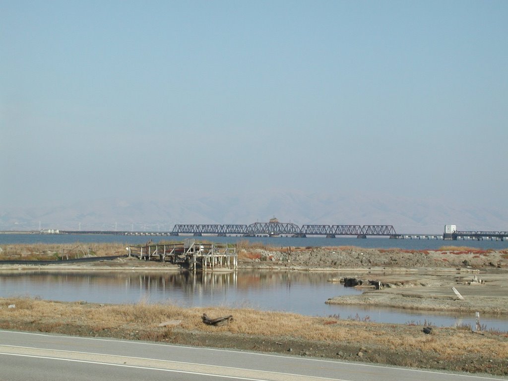
Monte Bello Open Space Preserve
 Date: 11/04/06
Park: Monte Bello Open Space Preserve, Los Altos Hills, CA
Condition: Sunny, cool but muggy and foggy
Start time: before 2:00 PM
Length: About 3 Hours (around 6 miles)
Hiker: JC, Maria, Louisa, Monica
Trail: http://www.bahiker.com/southbayhikes/monte.html
Map: Map
Pictures: http://jc-studios.smugmug.com/gallery/2094321
Views: The trail is very pretty and we took plenty of pictures. I thought there is a lone tree that I got pictures at 2 different angles last time. It turns out to be 2 totally different trees. There are views of the bay but it was quite foggy. The leaves are changing yellow and they were very pretty. The trail is shady for some part and other part is quite open. We expect it to get muddy since it rained for a couple days last week but it was not muddy yet. We saw a couple deers while driving and hiking. We also amazed at the full moon rising towards the end of the hike. All in all a very nice walk for the fall season. The only problem is the trail goes down first then up and also I got very sweaty while hiking up
星期六, 10月 14, 2006
Dumbarton Bridge 84 biking

Date: 10/14/06
Park: Don Edwards Wildlife Refuge, Newark, CA and Ravenswood Wildlife Refuge, Menlo Park, CA
Condition: Cloudy in the morning, Sunny and breezy
Start time: About 3:45 PM
Length: About 1 Hours
Biker: JC
Trail: AdHoc
Trail Map: N/A
Pictures: http://jc-studios.smugmug.com/gallery/2006437
Views: The bay, East Bay, Peninsula and fuzzy SF. The bridge and a few sloughs. The abandon railroad track across the bay. There are some tiny birds and long stilks black birds. It was quite windy that my helmet is flipping over my head. My visor is no longer protecting my eye. It is not as difficult as I anticipated. Next time I could bike further.
星期六, 10月 07, 2006
Portola State Park
 Date: 10/07/06
Park: Portola Redwood State Park/Pescadero Creek County Park, Woodside, CA
Condition: Sunny and cool
Start time: About 12:00 PM
Length: About4 Hours (around 5 miles)
Hiker: JC, Ceci
Trail: http://www.bahiker.com/southbayhikes/portola.html
Trail Map: Map
Pictures: http://jc-studios.smugmug.com/gallery/1978214
Views: The trail is quite shady for the most part and the weather is good for hiking. There are plenty of evergreen trees growing everywhere. Redwoods and others. The trail runs along Pascadero Creek for a while, we visited tip toe fall. The leaves are starting to turn orange and yellow but they are not extensive yet. We missed a turn at Old Haul Road and spent an extra hour there. The trail is a little bit tough at almost the end but it is not too bad. It rained previous days so plenty of banana slug on the trail. We were looking for five finger fern and huckleberry but couldn't figure out how they look like.
The drive back on 84 is so exciting but my passenger is fast asleep just like my other one.
星期六, 9月 30, 2006
Pinnacles National Monument
 Date: 09/30/06
Park: Pinnacles National Monument, Hollister, CA
Condition: Sunny and cool
Start time: About 12:00 PM
Length: About 5 Hours (around 5 miles)
Hiker: JC, Maria, Pak, Belinda
Trail: High Peak Loop, Condor Gulch, Moses Springs, Rim Trail
Trail Map: N/A
Pictures: http://jc-studios.smugmug.com/gallery/1956721
Views: We went to the East side again and we forgot to bring the map for Hollister. Mug wants to use that Google Mobile Search again. Uh oh.... It keeps on sending us directions. $0.10 per beep. Oh no... Actually, we did not get too far away from our right path. We got to a gas station, check the map and got back to the right track. When we got there, it was still a little bit cloudy. The sun peeked out towards the end of the hike. We got some nice pictures. We visited the Reservoir and it has plenty of ripples. The ripples are caused by frogs breathing under the water. We did not see any though. We pass though some caves towards the end and I fell and also hit my head. When we get back to the parking lot, I found I have blood on my pants. Anyway, it was just minor injury. We had a nice Italian Dinner at Gilroy and the waitress is very nice to us. A very good day.
星期六, 9月 16, 2006
Long Ridge
 Date: 09/16/06
Park: Long Ridge Open Space Preserve, Woodside, CA
Condition: Sunny and nice
Start time: About 2:00 PM
Length: About 2-3 Hours (around 5 miles)
Hiker: JC, Maria, Alan and Meiling
Trail: http://www.bahiker.com/southbayhikes/longridge.html
Trail Map: Map
Pictures: http://jc-studios.smugmug.com/gallery/1899521
Views: The trail is quite shady for the most part and the weather is good for hiking. There are layers and layers of mountains and evergreen trees grow everywhere. Redwoods and others. Several parts are quite steep and we need to rest along the climb. We saw an Elephant Idol beside the creek under the bridge. We wonder if it was some recent festival. We also walk by a pond overgrown by vegetation. We met a few mountain bikers a few times. Since the trail is not very long, less than 5 miles, next time we could extend the hike as suggested. We finished the hike pretty early and we drove down to highway 1 and visit the beach. We were very close to the waves. So cool. Somehow Maria asked me to bring a jacket when the weather is warm, I comply without hesistation (which is quite odd) and it became useful at the beach, I lend it to Meiling which is freezing. If they had all got enough clothes, I have been staying there to take more pictures. Anyway, this is good enough.
星期六, 9月 09, 2006
Stevens Creek Reservoir
Date: 09/09/06
Park: Stevens Creek Reservoir, Cupertino, CA
Condition: Sunny and quite hot
Start time: About 2:00 PM
Length: About 3 Hours (around 6 miles)
Hiker: JC, Maria, Shih-hsin, Cindy
Trail: http://www.bahiker.com/southbayhikes/stevenscreek.html
Trail Map: N/A
Pictures: N/A
Views: JC is so exhausted that she skip taking pictures. The reservoir is calm and pretty as usual. We found out that we were parking illegally for the past few times we came inside the parking lot. Thank God we did not get any ticket. JC needs to work out more or rehabilitate to walk. Left hand and feet are still quite stiff and inmobile. Hopefully it is only ergonormic problems and will go away soon once JC figure out what is causing them.
星期一, 9月 04, 2006
Sweeney Ridge
 Date: 09/06/06
Park: Sweeney Ridge Trail, Golden Gate National Recreation Area, Pacifica, CA
Condition: Sunny with some fog
Start time: About 2:00 PM
Length: About 3 Hours (almost 6 miles)
Hiker: Jeffery, Grace, Grace's sister, Lucian, Monica, James, Edison, Andrew, Renata, Toby, Timmy, Andrew, Jen, Maria, Sarah, Yvonne, JC Allen, Christine, Kenny
Trail: http://www.bahiker.com/southbayhikes/sweeney.html
Trail Map: Map
Pictures: http://jc-studios.smugmug.com/gallery/1855144
Views: A very nice day in Pacifica. There is a paranomic view around San Franciso. We saw views of Crystal Springs Reservoir, SFO, surrounding hills and the Pacific Ocean. We have 2 children with us and they finished the hike. Woohoo.... Good job!!! Plenty of Trees and some wild flowers. Plants everywhere. We stopped at the discovery site and view around with the binoculars. We trace a few Bay Area mountains there, Mission Peak, Mt Diablo. Hopefully it would be a clearer day next time for more mountain identification. Fog fell among us almost the end of the hike and it gets windy and cold.
星期六, 9月 02, 2006
Fall Creek Unit, Henry Cowell State Park
 Date: 09/02/06
Park: Henry Cowell State Park, Felton, CA
Condition: Sunny
Start time: About 1:50 PM
Length: About 4 Hours (almost 7 miles)
Hiker: Pak, Sarah, Yvonne, JC and Maria
Trail: http://www.bahiker.com/southbayhikes/fallcreek.html
Trail Map: N/A
Pictures: http://jc-studios.smugmug.com/gallery/1846235
Views: Plenty of redwood trees. Fall Creek and plenty of small waterfalls. Lots of fallen trees and exposed roots. Part of the trails are quite wet and muddy. JC is careful not to get overheat because parts of the trail are steep ascend. We were getting hungry after a while and Yvonne has granola bars so that we could regain some energy. Sarah, Yvonne, JC and Pak took some pictures. This is a nice shady trail for the summer. If the breeze is stronger, then it would be perfect.
星期六, 8月 26, 2006
Rancho San Antonio
 Date: 08/26/06
Park: Rancho San Antonio, Mountain View, CA
Condition: Sunny
Start time: About 4:00 PM
Length: About 2 Hours
Biker: JC and Maria
Trail: Wildcat Loop
Trail Map: http://www.openspace.org/preserves/maps/rancho_san_antonio_map.pdf
Pictures: http://jc-studios.smugmug.com/gallery/1820252
Views: We went to San Antonio so often, nothing is really spectacular. This time we notice some violet flowers, quail and some cotton like flower trees.
星期六, 8月 19, 2006
Don Edwards, Alviso
 Date: 08/19/06
Park: Don Edwards National Wildlife Refuge, Alviso, CA
Condition: Sunny with a cool breeze
Start time: About 2:30 PM
Length: About 1.5 Hours
Biker: JC and Maria
Trail: Ad-hoc
Trail Map: N/A
Pictures: http://jc-studios.smugmug.com/gallery/1798017
Views: Nice view of the East Bay. Water is green, blue and orange. Animals include squarril, egret, brown pelican, white pelican, sea gulls, stilks. The birds are sitting on the orange stuff. They look like land but in fact, I think they are some kind of moss or sea weed. We are going to a party afterwards so we did not finish the trail. It is a nice ride and the views are spectacular.
星期三, 8月 02, 2006
Zion and Bryce Canyon 5 day trip
 Date: 07/19-23/2006
Park: Zion National Park and Bryce Canyon National Park
Condition: Sunny, Hot, Extreme Temperatures, Thunderstorms
Hikers: Me, Maria, Pak
Maps:
Bryce Canyon National Park
Zion Nation Park
Pictures: http://jc-studios.smugmug.com/gallery/1702649
Day 0 Travel to Zion National Park, Zion Visitor Center
Day 1 Zion - Watchman Trail, Riverside Walk, Weeping Rock, Lower Emerald Pool (Kayenta Trail)
Day 2 Zion - Angel's Landing, Mt Carmel Highway, Drive to Bryce Canyon National Park
Day 3 Bryce - Rim Trail, Queen's Garden Trail/Navajo Loop, Viewpoints, Drive to N. Las Vagas
Day 4 Travel Home
Highlights:
Raining Cats and Dogs near LV on our way to Zion
Very Hot in Zion, almost got heat stroke the first day, had thunderstorms in the afternoon
Even hotter in Zion the second day, nearly need to be carried out by ranger. Another Thunderstorm approaching in the afternoon.
Happy Snapping the lightning in Bryce.
Better Temperature in Bryce, Hoodoos are awesome. Walking down the canyon is cool.
Saw Deer, Ravens, chipmunks, lizards
In this trip, switchbacks are my friend, can not spent a day without it.
Lesson Learnt: Bring plenty of water with Gatorade
Thank God for the experience and friendship and the wonderous creation
星期二, 7月 04, 2006
Marin Headlands/GG National Recreation Area
Date: 07/04/06
Park: Golden Gate National Recreation Area, Marin Headlands, CA
Condition: Sunny but not too hot with a nice breeze
Start time: About 1:30 PM
Length: About 3 Hours
Hiker: JC, Pak and Rachel
Trail: http://bahiker.com/northbayhikes/rodeobeach.html
Trail Map: http://data2.itc.nps.gov/parks/goga/ppMaps/map%2Dmahe%2Epdf
Pictures: http://jc-studios.smugmug.com/gallery/1636518
Views: Nice view of the Pacific Ocean. GG Bridge, Ocean Beach by the Great Highway. Plenty of wildflowers, violet, yellow, orange. Furry stuff, dandelion. Not much trees only some Cypress along the way. Animals include butterfly, I saw 1 dragonfly, some hawk, raven, a egret, brown pelican and plenty of other birds. We reverse the suggested hiking direction and also hike at the inner side of the lagoon instead. We also walk through the beach. It would be nicer if we follow the suggested trail since we will be hiking towards the ocean. Anyway, this is a nice trail for the summer. It was a warm day but the Ocean breeze keep us cool. To our suprise, the Golden Gate Bridge is also clear of any fog again.
星期六, 7月 01, 2006
Sanborn/Skyline County Park
 Date: 07/01/06
Park: Sanborn/Skyline County Park, Saratoga, CA
Condition: Sunny but not too hot with a nice breeze
Start time: About 3:00 PM
Length: About 3 Hours
Hiker: JC, Sarah and Maria
Trail: http://www.bahiker.com/southbayhikes/sanborn.html
Trail Map: http://www.sccgov.org/SCC/docs/Parks%20and%20Recreation,%20Department%20of%20(DEP)/attachments/332566sanborn%20both%20.pdf
Pictures: http://jc-studios.smugmug.com/gallery/1621657
Views: Not much view on this trail but there are plenty of odd looking rocks, some with holes, others have strange shape. This is also a nice trail in the summer, it is shady from beginning till the end. We saw some Redwood Trees, flowers, plants and butterfly. When we reach Indian Rock, I involunteryly donated my blood for some hungry mosquitoes. I have a dozen of bites on both legs and on my wrist. So itchy, man.
星期六, 6月 17, 2006
Hayward Shoreline
 Date: 06/17/06
Park: Hayward Shoreline, Bay Trail, Hayward, CA
Condition: Sunny and hot day but windy there
Start time: About 5:30 PM
Length: 2+ Hours
Biker: JC
Trail: Bay Trail from Hayward Shoreline Interpretive Center to Winton Ave
Trail Map: http://baytrail.abag.ca.gov/maps/East_Bay.pdf
Pictures: http://jc-studios.smugmug.com/gallery/1573583
Views: The Bay, East Bay Hills, San Mateo Bridge, Very faint San Francisco because there are a lot of haze. No clouds but very hazy. It was quite windy but not cold. The trail is quite cool since part of it is just next to the bay. Water is splashing on the trail. I decided to keep my camera in my backpack. Nice ride, not difficult at all. A part of the ride is next to a trash mount called Mt. Trashmore. Hahaha... cool name and very desciptive. I saw a few jack rabbits and squarrels. There are plenty of birds too, egret, sea gulls, stilks, ducks, sparrows. I cross a few bridges and there is a visitor center, there are lots of birds there. I finished biking at around 7:30 and decided to take pictures of the sunset around the visitor center. I ran out battery at around 8:30 or so. So the sun is not fully set. Too bad. Next time, I should have been there earlier and ride to Oyster Bay. I only got to Winton Ave this time, I did not find the trail to continue and after looking at the map, I found the way but decided to head back. This is a good trail for the summer.
星期一, 5月 29, 2006
Pt. Reyes National Seashore
 Date: 05/29/06
Park: Pt. Reyes National Seashore, Marin County, CA
Condition: Sunny and windy
Start time: About 3 PM
Length: We just play tourist and did not do serious hiking
Hiker: JC, Maria, Sarah, Mr. and Mrs. Mak, Pak, Ada, Ken
Trail: Lighthouse and Elephant Seal Overlook, Golden Gate Bridge Overlook
Pictures: http://jc-studios.smugmug.com/gallery/1514814
Short Video: http://www.youtube.com/watch?v=t87wolGxy3k
Views: Pacific Ocean, light house, Elephant Seals, Golden Gate Bridge. To our surprised, the weather is very sunny. No fog, not really cold. We got there pretty late but we had a nice relax lunch. We just walked around and listen to the Ranger explaining the history of the light house. We had Oysters at the same grocery store as we did last time. Too bad we missed the Gray Whale migration period. Nice weather, plenty of wild flowers. Animals include Falcon, and red headed eagle like bird. Since Golden Gate Bridge is so cleared. We dropped by when we return for pictures. We should get there earlier next time.
星期六, 5月 20, 2006
Morgan Territory
 Date: 05/20/06
Park: Morgan Territory, Livermore, CA
Condition: Cloudy and not hot
Start time: About 3 PM
Length: More then 3 hours (4.7 miles)
Hiker: JC
Trail: http://www.bahiker.com/eastbayhikes/morgan.html
Pictures: http://jc-studios.smugmug.com/gallery/1477557
Views: Livermore Valley, Mt Diablo. There are plenty of birds singing, although I only seen a few birds but I heard plenty of different birds singing. I saw a hawk, red winged black bird and squarrel. From start till finish the crickets and the bird continue singing. There are crows calling and also some sounds like cat. I saw a few dogs and a couple esqustrians. The drive to the park is a good one, execellent views, vinyards, green hills, but needs to be real careful since it is a single lane road. I was disappointed early in the trail, finding only scattering white flowers. As I walk further and futher then there are more flowers and more varity. At one point I saw more then 50+ cows. They were on the trail. I have to walk between them to make sure I did not scare them. After a while, I lost the trail. Finally after walking between more cows, I found it again. The trail come to a gate, a cow on each side of the gate. Oh my, how could I get through without scaring them. I sneek behind the first cow and squeeze through the gate, making sure I did not let it escape to the other side. Then I slowly walk toward the other cow on the other side. Luckily it walked away. Almost towards the end, there is a long steep climb. My nose could not be turned off, my eyes are all swollen when I got home. But this trail is worth the misery.
星期六, 5月 13, 2006
Baylands Park
 Date: 05/13/06
Park: Baylands Park, Sunnyvale, CA
Condition: Hot but breezy
Start time: About 2:30 PM
Length: About 4 hours
Biker: JC, Maria
Trail: Ad-hoc
Pictures: http://jc-studios.smugmug.com/gallery/1456619
Views: Moffett Field, East Bay, Dumbarton Bridge, Hwy 237. We even saw some sort of Rader tower at the trail. Animals and birds include: Eagle or some kind of hawk, red winged black bird, slits, white goose, Candian goose, ducks, gooselings, ducklings, humming bird and some unknown bird that sings beautifully. As we are backtracing our trail, we saw a very long snake in the middle of the trail, it was enjoying the late afternoon sun just like us. It was not scared and we stayed there a watch it for a long time. We did not go too close and use a binocular to watch it. It is slithering its tongue all the time. We saw a much smaller one just a little bit futher. We park outside the park so we saved $5 and bike into the park. We even got a nice shady spot for the car. Thank you Lord for this memoriable trip. I even dreamt of the snake that it finally coiled up on the side. Hahaha....
星期六, 5月 06, 2006
Joseph D Grant County Park
 Date: 05/06/06
Park: Grant County Park, San Jose, CA
Condition: Warm and nice
Start time: About 2PM
Length: About 4.5 hours
Hiker: JC, Maria and Sarah
Trail: http://www.bahiker.com/southbayhikes/grant.html
Pictures: http://jc-studios.smugmug.com/gallery/1435755
Views: San Jose, Bay Area and Lick Observatory. We walked by Grant lake and did not go to Bass Lake. There are some waterfalls along the way. Animals and birds include: Eagle or some kind of hawk, plenty of unamed bird, red winged black bird, rabbit, squarrel, turkey like bird. Dragonfly, butterfly, ants, and an insect that looks like wingless bee. We heard some frogs jumping into the water and tadpole in the lake. We saw some fishermen at Grant Lake. There are plenty of wild flowers, red, yellow, violet color. It is breezy so it does not feel very hot. Sarah is getting近朱者赤近「麥」者黑。Hopefully we do not give her bad influence. The sign postings are very confusing, we got lost and hike an extra mile. All in all, it is a nice hike and it has climbs but not too bad for old person like me.
星期六, 4月 29, 2006
Don Edwards, Fremont
 Date: 04/29/06
Park: Don Edwards Wildlife Refuge, Fremont, CA
Condition: Hot but Windy
Start time: About 4:30PM
Length: About 1 hours
Biker: JC
Trail: Ad-hoc
Pictures: http://jc-studios.smugmug.com/gallery/1420592
Views: Dumbarton Bridge and the Peninsular, SF not visible that day. Animals and birds include: Eagle or some kind of hawk, ducks, Canadian Geese. This is after rebuilding together volunteering and my first ride after a long time so I end up pushing my bike up the hill most of the time. I would go again soon so that I know I have improved. The road that goes all the way to the side of 84 is closed because of nesting birds, otherwise, I would have ride across the bridge. Anyway, it was quite cool to ride above all the traffic of Hwy 84 to the quarry trail at Coyote Park.
星期日, 4月 02, 2006
Don Edwards Wildlife Refuge
 Date: 04/01/06
Park: Don Edwards Wildlife Refuge, Alviso, CA
Condition: Cloudy, Cold and Windy
Start time: About 2:30PM
Length: About 1 hours
Hikers: Maria and JC
Trail: Ad-hoc
Pictures: http://jc-studios.smugmug.com/gallery/1330737/1/62749657
Views: East Bay, the bay. Animals and birds include: Sea Gulls, Egret, Pelicans, Canadian Geese, squarrels and rabbits. The rabbits are hiding under the deck and under the building. We saw a pump pumping water out to the bay. The water was quite foamy. The water level is very high and it is almost as high as the wooden deck. We got lots of rain this year that is why the water is high. I wonder if we are getting high tide also. When we start the hike, I drop my camera cover into the water. Luckily the water is full of moss or water weed so the water tension is very high that the cover still floats. I can lean over and got it back. Phew! What a close call..... My camera cover and my hand contaminated the water though. Or they have contaminated me. I think if the water level is not high nor if there are moss growing. I will have to buy a new camera cover. Hahaha...
星期六, 3月 25, 2006
Bayland Park
 Date: 03/25/06
Park: Bayland Park, Palo Alto, CA
Condition: Cold and Windy and some rain
Start time: About 1PM
Length: About 2 hours
Hikers: Sarah, Maria and JC
Trail: Ad-hoc
Pictures: http://jc-studios.smugmug.com/gallery/1306509/1/61537825
Views: Shoreline Lake, East Bay, Mountain View, Dumbarton Bridge. Animals and birds include: Sea Gulls, Egret, Canadian Goose, and furry insects 毛毛虫. We were hiking and some rain got us. All in all, not enough rain to get us wet so it is fine. Some of the water are strangely reddish in color. But I have seen reddish water around the bay, I have seen it in the East Bay Don Edwards National Wildlife Refuge. A black and yellow stripe body spider (color stripe like a bee) followed us into my car. The body is as big as a quarter. It crawl on my hand when we were way out of the park. It wanted to follow us home. Hahaha.... Some one was so scared..... Hahaha..... Not me. Hahaha.... I was driving and is so calm. I just open the window and shake it off.......
星期六, 3月 18, 2006
Monte Bello Open Space Preserve
 Date: 03/18/06
Park: Monte Bello Open Space Preserve, Woodside, CA
Condition: A lot of Sun with Haze and a bit cool
Start time: About 2PM
Length: About 5.3 Miles
Hikers: Maria and JC
Trail: http://www.bahiker.com/southbayhikes/monte.html
Pictures: http://jc-studios.smugmug.com/gallery/1287616/1/60514385
Views: A paranomic view of the bay area and sunsets. Animals included a coyote, a few deers. Not much wild flowers yet. We saw a big sag pond with plenty of vegetation. The trail is a little bit muddy with sometimes small streams flowing along it. The mud is yellowish in color. Wong Nei Chung. Waterfalls are common. A portion of the trail is along Stevens Creek, which the water flow is quite rapid. We went just after a few days of constant spring rain and weird California weather so the water is abundant. There are some trees that the leaves looked like flowers. Funny event is I spend a lot of time looking for places that I could hide doing natural things, twice. And nothing more to go when there is a real toilet. Hahaha.... It took us 4.5 hours to finish the hike because of this delay.
星期六, 2月 25, 2006
Stevens Creek Reservoir
 Date: 02/26/06
Park: Stevens Creek Reservoir, Cupertino, CA
Condition: Warm and Sunny with Haze
Start time: About 12PM
Length: About 6.1 Miles
Hikers: Noelle, Maria, Sarah, JC
Trail: http://www.bahiker.com/southbayhikes/stevenscreek.html
Pictures: http://jc-studios.smugmug.com/gallery/1234681/1/57827851
Views: The reservoir was pretty as usual, I forgot to bring the description print out. We have been there a few times so we did not get lost. I thought we made the wrong but in fact we didn't. Thank God. We saw quite a lot of new plants growing after the pouring rains. The place is so full of life. We went up to the vista point and the bay area is the view. It was a little bit hazy though. I was kinda sick that day so walking and resting on the way up. I was walking soooooooooooo sssssssllllllllooooooooowwwwwwwlllllllyyyyyy. Anyway it is nice to breathe cleaner air. There are a few kayaks on the water which makes the pictures more interesting around the green trees, green water and the green hills. There were a few blue Jays and other birds. We also saw 2 rangers with a radar gun to catch speeding bikers.
星期一, 2月 20, 2006
Mission Peak
 Date: 02/20/06
Park: Mission Peak, Fremont, CA
Condition: Windy and Sunny
Start time: About 12:45 PM
Length: About 4 hours
Hikers: JC
Trail: http://www.bahiker.com/eastbayhikes/missionpeak.html
Pictures: http://jc-studios.smugmug.com/gallery/1225321/1/57381141
Views: I was planning to see snow covered Mt Diablo and Mt Hamalton, neither was snow covered. San Francisco is not visible either, too hazy. But the view is still awesome. A lot of noisy cows and calves calling, running and eating. Very green hills. A few eagles/hawks. A perichute jumper. An insect that looks like bees without wings. Wild flowers are not abundant yet. Just a tree with flowers.
星期六, 2月 11, 2006
Los Trancos
 Date: 02/11/06
Park: Los Trancos Open Space Preserve, Woodside, CA
Condition: A warm spring day.
Start time: About 3:00 PM
Length: About 3 hours
Hikers: Maria and JC
Trail: http://www.bahiker.com/southbayhikes/lostrancos.html
Pictures: http://jc-studios.smugmug.com/gallery/1197187/1/56004650
Views: This is on the San Andreas Fault and it is a nature trail which explains the geological features. We saw a fence split by the American Plate and Pacific Plate. Ground water generate source of the creek. A few water falls. There are trees that had almost fall but still have little bit of soil attached to the roots, branchs grows vertically. We still couldn't figure out what is roadlike bench. This is a short walk but plenty of elevation drops and climbs.
星期日, 2月 05, 2006
Rancho San Antonio
 Date: 02/05/06
Park: Rancho San Antonio, Los Altos, CA
Condition: A very nice day.
Start time: About 3:45 PM
Length: About 2 hours
Hikers: Maria, Ceci, Hillary, Rachel, JC
Trail: The usual Wildcat Loop Trail
Condition: Nice and warm.
Pictures: http://jc-studios.smugmug.com/gallery/1183387/1/55343059
Views: A very clear day with views of SF at the vista point. The whole peninsular is in sight also. We went there after church, the farm is still open when we got there. We seldom got there when it is still open but there were only a few chickens and cocks. All other farm animals are hiding. Oh well, may be next time. Hillary and Rachel seemed to enjoy the hiking a lot. We should take them along for hiking more. It is near dusk so the wild animals came out. We saw several quails, a rabbit, a few deers and a bob cat. We even saw a domestic cat which ignores us.
星期六, 2月 04, 2006
Don Edwards Wildlife Refuge
 Date:02/04/06
Park: Don Edwards Wildlife Refuge, Alviso, CA
Condition: Nice with some clouds
Start time: About 4:30PM
Length: Approximately 1 hours
Trail: ad hoc, started at Gold Street Marina, Alviso
Hikers: Me, Maria
Pictures: http://jc-studios.smugmug.com/gallery/1183296/1/55339191
Views: Sunset is nice, the clouds are colorful. We even saw a patch of clouds with rainbow color. Normal winter wind. We saw a lot of birds and an Amtrak. After the Amtrak passed by, most of the birds evacuated the water. May be it is the noise or may be it is the shaking. The view consisted of the East Bay with sunset green hills. Sunset over the Western Hills, too bad the reflection on the water was not too great. The trail was a little bit wet but it was manageable. We started late because we started after Fr Andrew's liturgy retreat. Overall, a short stroll with very nice views.
星期六, 1月 28, 2006
Shoreline Park
 Date:01/28/06
Park: Shoreline Park, Mountain View, CA
Condition: Cloudy and the sky looks like falling
Start time: About 3:30PM
Length: Approximately 2 hours
Trail: ad hoc
Hikers: Me, Maria, Potato
Pictures: http://jc-studios.smugmug.com/gallery/1168622/1/54587941
Views: Too cloudy for any sunset, the sun does not peek out at all. Luckily it did not rain like the forecast said. We saw plants that have flowers looking like bottle cleaner. A crane, a duck. Our trail pass by Rangstroff house, shoreline ampitheatre, the kite area also. Originally I was thinking of going at Steven's Creek Trail, because I saw the sign to the trailhead. But we got lost finding the trail head so finally we just went to a familar place. The famous Shoreline Park!!! Hahaha...
星期日, 1月 22, 2006
Los Alamitos Creek
 Date:01/21/06
Park: Almaden Lake Park, Los Alamitos Creek Trail, San Jose, CA
Condition: Cloudy
Start time: About 2:30PM
Length: Approximately 4 miles
Trail: http://www.bahiker.com/southbayhikes/alamitoscreek.html
Hikers: Me, Maria, Sarah, Margret
Pictures: http://jc-studios.smugmug.com/gallery/1145058/1/53372873
Specifics Views: It was a flat one. Not much of a paranomic view. But we caught the sunset and a few deer sightings. There were naked trees and birds singing. There are few birds flying too. I wonder how birds live in bare trees. May be they are camping??? Hahaha.... The trail is a jogging trail and we did the exercise on the side of the trail. It has a swimming beach for the summer crowd and jogging, biking trail. There is a playground also. Sarah gets cold after the sun sets and was jogging which is the trail intended for.
星期六, 1月 14, 2006
Death Valley Christmas Trip
 Date: Christmas 12/23-27 2005
Park: Mohave Preserve and Death Valley, CA
Condition: Sun and Clouds, no rain
Trail: No specific record
Hikers: Me, Mug, Sarah, Pak
Pictures: http://jc-studios.smugmug.com/gallery/1079516/1/51490384
Day 0 Travel to Mohave
Day 1 Mohave Hole in the Wall trail, LV Christmas Eve Buffet and Mass
Day 2 Travel to DV, DV Sand Dunes
Day 3 DV Zabriskie Point Sunrise, DV Fall Canyon, DV Ubehebe Crater
Day 4 DV Wildrose Peak, Travel home
Highlights: Drive by plenty of plants; Spent plenty of time looking for hole in the rock trail; Almost ran out of gas in the middle of nowhere; 2 hour long wait for the buffet; Longer than expected 45 minutes walk to Church to attend mass; Watch plenty of sunrise and sunsets; No Rain; Slide down the Sand Dunes; Watches sunrises; See a rainbow; Yell for long delay echoes in the canyons; Fell down on my knees in front of Maria at Dry Fall; Camera ran out of battery at Ubehebe Crater; Cloudy at Wildrose; Take plenty of pictures overall; We had climb high mountains and go beneath the sea. We had argued and stop arguments. We had fight and made up. We were enjoying ourselves overall.
訂閱:
文章 (Atom)